
A Week's Grace for Comments on LDP2 and related documents
While the official deadline to submit comments on a) the Proposed Local Development Plan (LDP2), b) additional sites proposed by developers, and c) related policy documents has now passed, we have requested that comments received by 5pm on 22 January be looked at too, and this has kindly been agreed by planniung officers at East Dunbartonshire Council.
All relevant documents can be found here: https://www.eastdunbarton.gov.uk/proposed-local-development-plan-2.
There are also comment forms to complete and send to [email protected].
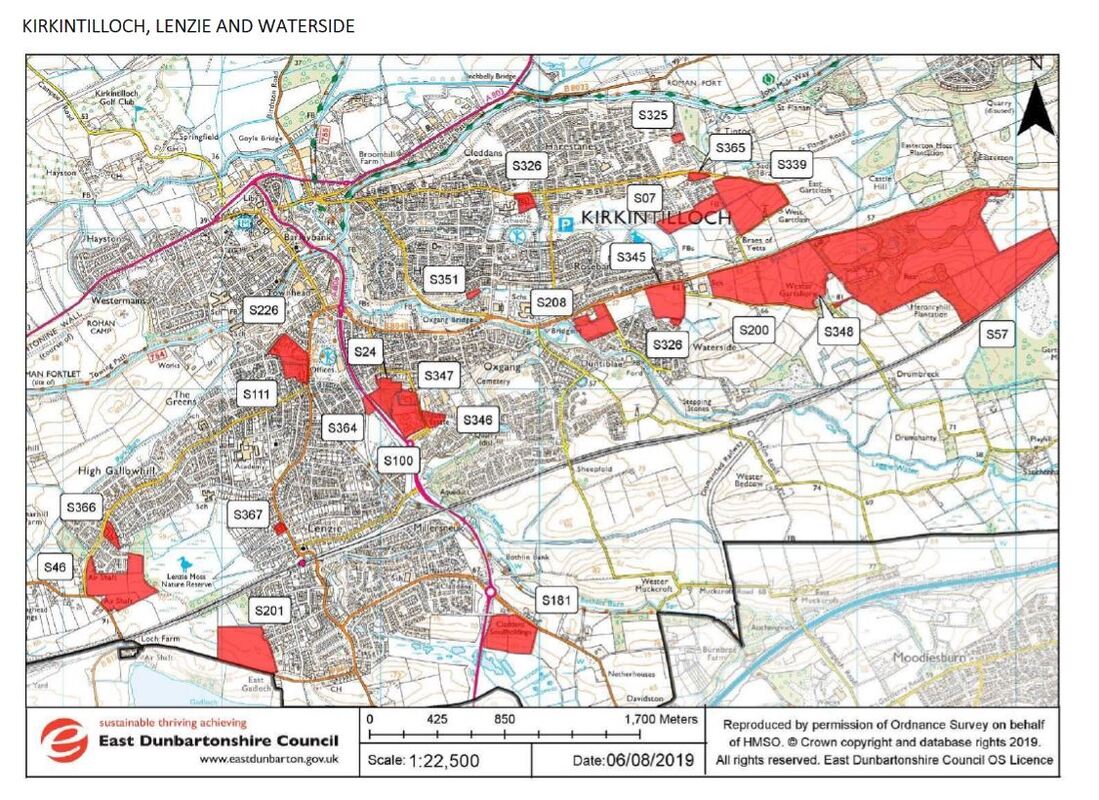
For your information, below are comments submitted by Waterside Community Council on local sites together with maps and details from council documentation.
All relevant documents can be found here: https://www.eastdunbarton.gov.uk/proposed-local-development-plan-2.
There are also comment forms to complete and send to [email protected].
For your information, below are comments submitted by Waterside Community Council on local sites together with maps and details from council documentation.
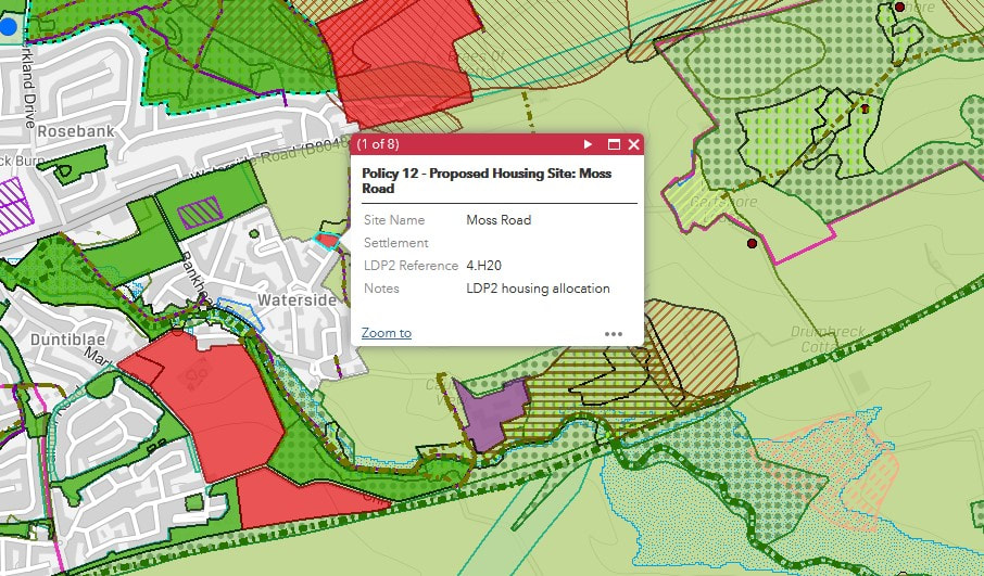

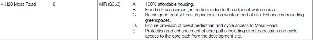
4.H20 Moss Road
While Waterside Community Council approves in principle of the idea of increasing the availability of social housing, Moss Road (like the rest of Waterside) already lacks sufficient parking spaces, and if the five garages on the land proposed for development are lost, even more cars will be forced to try to park on the street. Please note that drivers are currently forced to weave in and out of parked cars on either side of narrow Moss Road. One of the aims stated in the Waterside Community Action Plan 2019-2024 is to “improve parking” and to “work with local council to explore ways of improving the safety issues around car parking in the village.” Adding to the cars needing to park on Moss Road goes against this.
Additionally, more housing on Moss Road would contribute to an increase in traffic in existing problem areas:
As Moss Road leads to the school path (the main access route for primary children walking to Gartconner Primary School from Waterside), an increase in traffic on Moss Road is undesirable both from the road safety point of view and from the air quality one (air pollution is now recognized as a cause of death).
Local knowledge and experience leads us to believe that flooding issues at the bottom of Moss Road in connection with the Moss Goat Burn and marshland may make this area undesirable for building too. For instance, an area of grass beside the garages had a bin on it which Moss Road residents asked to be moved since they could not access it without sinking into mud and water.
Waterside opposes this development for the above reasons.
While Waterside Community Council approves in principle of the idea of increasing the availability of social housing, Moss Road (like the rest of Waterside) already lacks sufficient parking spaces, and if the five garages on the land proposed for development are lost, even more cars will be forced to try to park on the street. Please note that drivers are currently forced to weave in and out of parked cars on either side of narrow Moss Road. One of the aims stated in the Waterside Community Action Plan 2019-2024 is to “improve parking” and to “work with local council to explore ways of improving the safety issues around car parking in the village.” Adding to the cars needing to park on Moss Road goes against this.
Additionally, more housing on Moss Road would contribute to an increase in traffic in existing problem areas:
- at the junction with Berryknowe/Alexander Place, where there have been reports of a number of near traffic accidents
- on the already busy Bankhead Road, where parking outside cottages means traffic can pass in only one direction at a time
- on Cairnview, where the issue of traffic using it as a short cut and endangering children playing on the street has already been raised at community council meetings
- at the Cairnview/Bankhead Road junction, where drivers complain of insufficient visibility from Cairnview of traffic passing the junction along Bankhead Road on their way out of the village.
As Moss Road leads to the school path (the main access route for primary children walking to Gartconner Primary School from Waterside), an increase in traffic on Moss Road is undesirable both from the road safety point of view and from the air quality one (air pollution is now recognized as a cause of death).
Local knowledge and experience leads us to believe that flooding issues at the bottom of Moss Road in connection with the Moss Goat Burn and marshland may make this area undesirable for building too. For instance, an area of grass beside the garages had a bin on it which Moss Road residents asked to be moved since they could not access it without sinking into mud and water.
Waterside opposes this development for the above reasons.
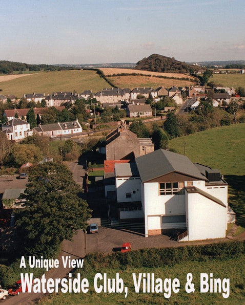

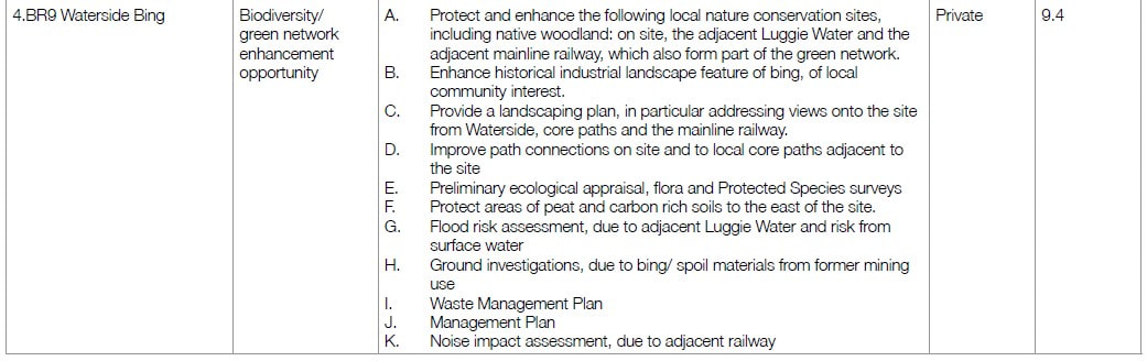
4.BR9 Waterside Bing
The Waterside Bing is an attraction for walkers from all around the area excited by climbing, beautiful views, East Dunbartonshire’s coal-mining history, wildlife, or getting fit. It has become a particular magnet for people from the wider area since COVID-19, when so many more have decided to make the most of the walks within reach.
Waterside Community Council supports the retention of the Waterside Bing as a Local Nature Conservation Site and its being allowed to continue playing an important role in nature and biodiversity. We also support any improvements in the core path network providing access to the Bing: improvements in the paths beside the Luggie Water and a new bridge to replace the condemned Wester Gartshore one would allow even more people to appreciate this landmark (with its significant role in local industrial history) and to benefit from the health, wellbeing and tourism opportunities it provides – the climb to the top, from where there is a wonderful 360-degree view of the Campsie Fells, Tinto Hill, Goat Fell on Arran, farms, rolling farmland and pastoral scenes. There is also a very pleasant walk around the bottom of the Bing for those who prefer a flatter walk. There is very little public space locally, so supporting public access to this area is particularly important for local health and wellbeing.
The Waterside Bing is a landmark too for all those using the Glasgow-Edinburgh railway.
As is clear from the above, Waterside Community Council supports the Bing remaining at its current height because of the views, the wildlife that has colonized it, and to avoid the risk of contamination to the nearby Luggie Water were it disturbed.
We must add that Waterside Community Council would never support removal of spoil through the village because of the inconvenience and risk to residents and because of the potential for damage to old cottages that vibrations from heavy lorries transporting it would bring.
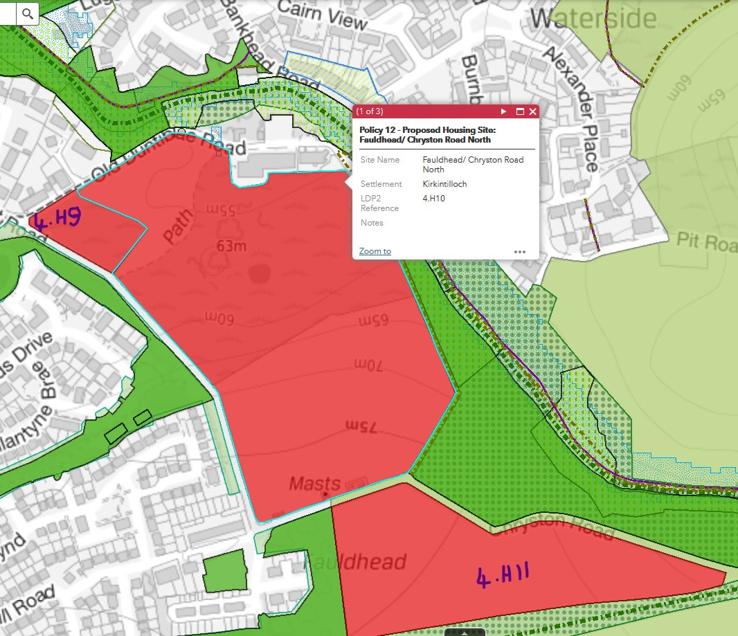
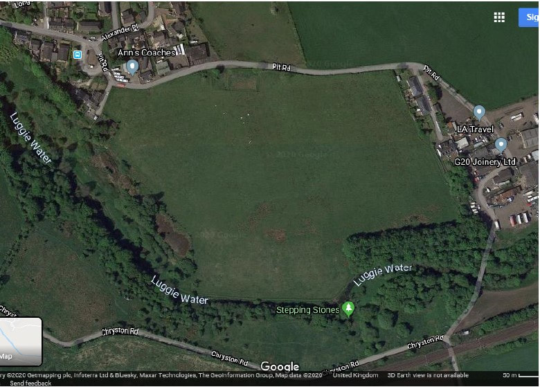
4.H10 Fauldhead/Chryston Road North, 4.H11 Fauldhead/Chryston Road South, 4.H9 Duntiblae
Waterside Community Council remains unhappy with the decision to zone all three of the above sites for development in LDP1, since building here would represent a massive loss to green belt, habitat connectivity and, in the case of 4.H10 and 4.H11, space used for exercise by Woodilee, Fauldhead, Duntiblae and Waterside residents (more important than ever since COVID-19). The area described as 4.H10 Fauldhead/Chryston Road North contains a beautiful mound, bluebell wood and lochan that play an important part in our local landscape, and the whole area is popular with walkers (including those taking part in bat walks). While the mound, trees and lochan are to be spared the bulldozer, they will no longer be part of a beautiful landscape if these developments go ahead. We note the major negatives shown in Appendix F of the Environmental Report for landscape (all 3 sites), population and human health (2 sites – a minor negative for the other), and water quality (1 site), as well as the minor negatives for biodiversity, flora and fauna as well as material assets, among others. We also note that there were no positives for any of the sites. These are clearly not cases of “the right development in the right place”; we would therefore ask East Dunbartonshire Council to reconsider whether allowing so much green landscape to be developed makes sense at a time when Scottish wildlife is under grave threat, Scotland's human population needs green space for its physical and mental health, and migration patterns and the COVID-19 financial hit may mean expensive new housing is less in demand.
Waterside Community Council remains unhappy with the decision to zone all three of the above sites for development in LDP1, since building here would represent a massive loss to green belt, habitat connectivity and, in the case of 4.H10 and 4.H11, space used for exercise by Woodilee, Fauldhead, Duntiblae and Waterside residents (more important than ever since COVID-19). The area described as 4.H10 Fauldhead/Chryston Road North contains a beautiful mound, bluebell wood and lochan that play an important part in our local landscape, and the whole area is popular with walkers (including those taking part in bat walks). While the mound, trees and lochan are to be spared the bulldozer, they will no longer be part of a beautiful landscape if these developments go ahead. We note the major negatives shown in Appendix F of the Environmental Report for landscape (all 3 sites), population and human health (2 sites – a minor negative for the other), and water quality (1 site), as well as the minor negatives for biodiversity, flora and fauna as well as material assets, among others. We also note that there were no positives for any of the sites. These are clearly not cases of “the right development in the right place”; we would therefore ask East Dunbartonshire Council to reconsider whether allowing so much green landscape to be developed makes sense at a time when Scottish wildlife is under grave threat, Scotland's human population needs green space for its physical and mental health, and migration patterns and the COVID-19 financial hit may mean expensive new housing is less in demand.
Additional sites proposed by developers


Pit Rd S369
Waterside Community Council strongly opposes any development at Pit Rd S369.
This area of pasture land (used for dairy cows) is part of the green belt that ensures Waterside retains the rural feel and village identity that residents value so much. Green scenery and plant life are now recognized to play an important role in physical and mental health, with hospital patients who have a view of trees or nature recovering faster and needing fewer painkillers than ones without, and the volatile organic compounds from plant life having a role in lowering blood pressure, for instance. It would therefore be completely wrong to deprive Waterside of any more of its most valuable assets for local wellbeing: its remaining green spaces. The field in question borders country walks along the Luggie Water, which would be very detrimentally altered should building be permitted here. Development would be completely at odds with the Waterside Community Action Plan 2019-2024, which says that “Waterside will offer accessible paths and walks in a beautiful landscape” and “will continue to be a green place full of trees and flowers.” Another aim stated in the action plan is to “keep our green space” and to “work with East Dunbartonshire Council and other appropriate agencies and support agencies to maximise and protect our green space.”) Because the landscape beside Pit Rd is hilly, any housing would rise up and spoil the village’s beautiful valley setting.
From a biodiversity and wildlife perspective, development on this area would be very damaging to habitat and green network connectivity with the Luggie wildlife corridor, as highlighted in the SEA summary. It would also remove species-rich grassland, as the SEA also notes. Given the terrifying species loss we are experiencing in Scotland, as all over the world, we need to ensure natural landscapes and wildlife habitat are not sacrificed: change of land use is cited by environmental agencies as the major factor in the decline of biodiversity and has a direct impact on the survival of both flora and fauna.
From a traffic point of view, Waterside has only one access road, Bankhead Road, which, because of necessary parking along one side, allows traffic in only one direction at a time beside the old, scenic cottages. Given that Waterside is not well served by public transport, were some 150-170 new houses to be added on Pit Road, this would inevitably cause severe congestion while completely changing the character of our village. There is a stretch of Bankhead Road that has no pavement and which coincides with a blind bend. Additional traffic on this road would make it more worrying and dangerous for pedestrians than it is currently. At peak hours the extra traffic waiting at the junction between Bankhead Road and Waterside Road would be likely to cause queues back to the cottages (as demonstrated in a traffic simulation carried out by the Waterside Action Group in relation to the extra traffic relating to the proposed ASN school in Waterside) and traffic jams, resulting in pollution and poorer air quality thanks to the particulates from tyre wear and exhaust fumes.
We note and agree with the following SEA comment in the assessment summary:
"The site is in a remote location in relation to the town centre and associated facilities and amenities so given the size of the site (and scale of the estimated development), it is therefore likely to significantly increase the need to travel with an emphasis on private vehicular travel."
With regard to water run-off and flooding, the land on the field is significantly higher than the cottages below (Muirhead Cottages). There are also springs in the area, which means there is a great deal of water beyond rain. A large development has the potential to cause a flooding risk for those on the lower ground and to increase the amount of water draining into the Luggie Water, with the consequent risks that brings to those downstream.
Waterside Community Council believes that now that the UK is outside the European Union, it has become more important than ever not to sacrifice farming land to development. Scotland and the UK in general may well need to become more food-secure in order to avoid an escalation in the cost of living having a very negative effect on more disadvantaged families, something that is particularly relevant to Waterside, which does not score well on the Scottish Index of Multiple Deprivation when looked at separately from Rosebank.
From a social, community perspective, Waterside works well as it is. There is a strong village identity, people greet others they meet in the street, and villagers tend to support their neighbours and other members of the community as required. There are currently some 430 dwellings. Another 170 houses would dramatically alter the character of the community and would change the dynamic. Gartconner School is currently very full, so a further question is, where would the children of any new residents be educated?
Finally, we believe that in a post-Brexit, post-COVID world, there may well be less migration to East Dunbartonshire, and some developments could well become surplus to requirements. New developments now have the potential to end up like the half-finished, half-occupied schemes seen in some other European countries where the housing market has suddenly crashed.
This proposed development that would have so many negative effects on the Waterside community MUST be resisted.
|
|

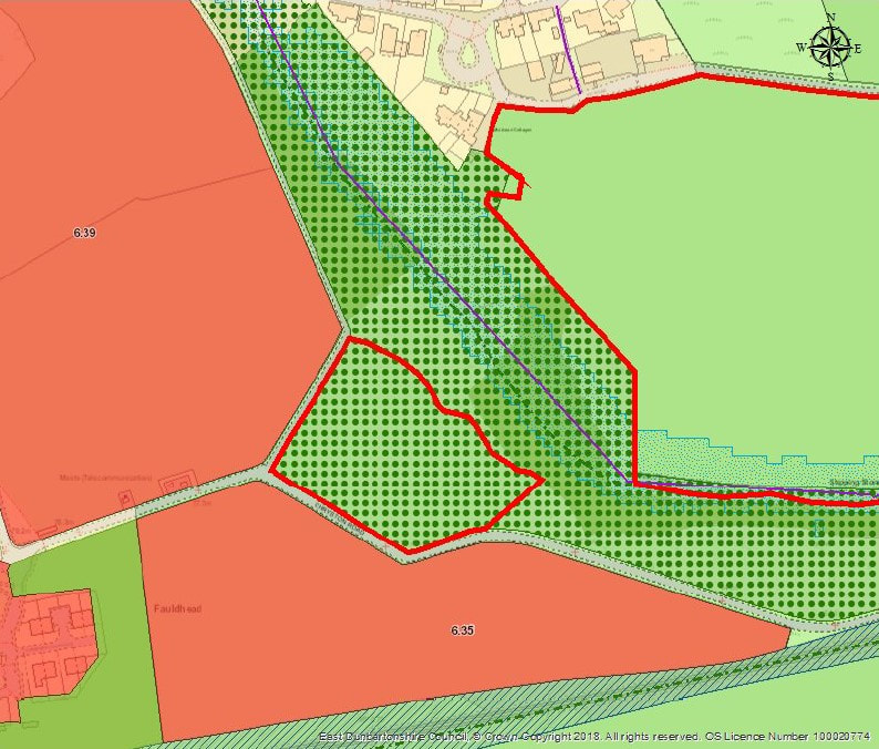
Fauldhead South S370
Waterside Community Council strongly opposes any development at the area described as Fauldhead South 370.
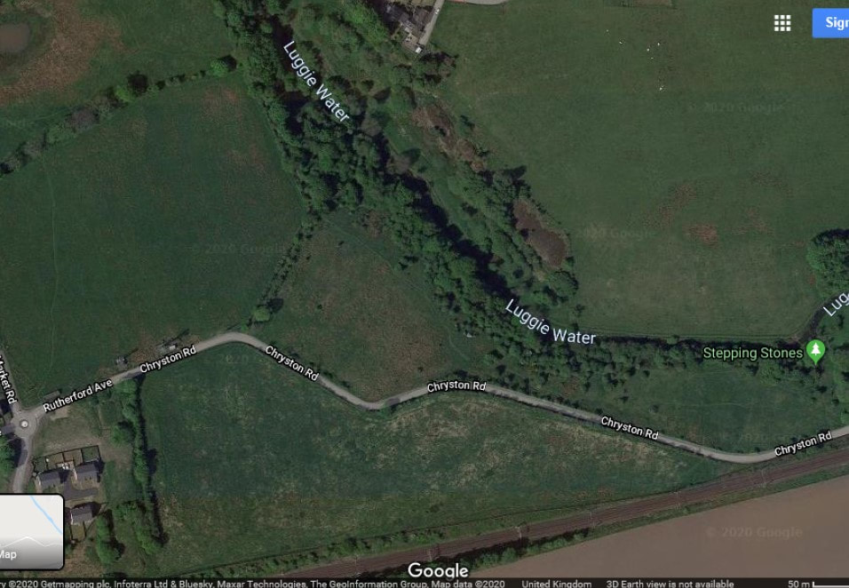
This meadow is a Local Nature Conservation Site and is part of the Luggie wildlife corridor. Plant life on the area (pignuts, for instance) shows that it has lain undisturbed for decades. Retaining areas of natural landscape is supremely important for the survival and wellbeing of our wildlife, whose habitats have been significantly reduced year on year (the State of Nature 2019 Scotland report found that average numbers across 352 species of mammals, birds, butterflies and moths had fallen 24% since 1994). We need to remember what the ED Green Network Strategy 2017 says on page 31, “Habitat fragmentation and isolation is considered to be a primary cause of biodiversity loss and the protection and enhancement of habitat corridors can aid in the reversal of the effects of habitat fragmentation on biodiversity”, and retain this meadow unspoiled.
Natural landscape is also vitally important for human communities, who are being increasingly deprived of the green space so necessary to our physical and mental wellbeing. Fauldhead, Woodilee, Duntiblae and Waterside residents, among others, all use this meadow, accessing it from Chryston Road, the Dam Braes footpath and the stepping stones over the Luggie. They use it for walks, dog exercise, brambling and peaceful contemplation, often from the seat in the centre of the area identified as S370, from where there is a beautiful view of rolling scenery, woodland, the Luggie Water, Waterside and the Campsies. Local residents have already lost the natural landscape of the Woodilee area for exercise (and are likely to lose Fauldhead/Chryston Road North 4.H10, Fauldhead/Chryston Road South 4.H11, and 4.H9 Duntiblae (agreed under LDP1), with their recognized major negatives for population and human health and landscape, among other things). For the sake of our wellbeing, we cannot afford to lose more. An aim stated in the Waterside Community Action Plan 2019-2024 is to “keep our green space” and to “work with East Dunbartonshire and other appropriate agencies and support agencies to maximise and protect our green space; maximise and protect our natural habitats, including woodland; maximise and protect our local open space.” The loss of this meadow would go completely against this aim. Please note that Waterside has very little public space; most of that used by residents for exercise and recreation (such as this meadow) is privately owned land. If the council does not take steps to protect it, the health and wellbeing of residents will be sacrificed.
Additionally, Waterside Community Council sees the area described as Fauldhead South S370 as important for the beautiful, natural setting of Waterside. And it is part of the green belt that prevents adjacent settlements merging into one sprawling, urban conglomeration. Building here would also change the character of the unspoiled, natural river walks along the Luggie, which would be a tragedy for this community and future generations.
We believe that in a post-Brexit, post-COVID world, there may well be less migration to East Dunbartonshire, and some developments could well become surplus to requirements. New developments now have the potential to end like the half-finished, half-occupied schemes seen in some European countries where the housing market has suddenly crashed. For this reason, among others, developments should be resisted on open space and green belt like Fauldhead South S370.
As a more general point, Waterside Community Council supports all endeavours to reduce the human footprint on Scotland’s remaining natural landscape. Human encroachment on wildlife habitats is contributing hugely to the species extinctions that have gathered pace in recent years (change of land use is cited by environmental agencies as the major factor in the decline of biodiversity and has a direct impact on the survival of both flora and fauna). Those in positions to stop the march of human destruction in today’s world owe it to us and to our descendants to do so. Fauldhead South S370 should be left as the unspoiled meadow and vital part of the Luggie Water wildlife corridor that it is today.
Waterside Community Council strongly opposes any development at the area described as Fauldhead South 370.
This meadow is a Local Nature Conservation Site and is part of the Luggie wildlife corridor. Plant life on the area (pignuts, for instance) shows that it has lain undisturbed for decades. Retaining areas of natural landscape is supremely important for the survival and wellbeing of our wildlife, whose habitats have been significantly reduced year on year (the State of Nature 2019 Scotland report found that average numbers across 352 species of mammals, birds, butterflies and moths had fallen 24% since 1994). We need to remember what the ED Green Network Strategy 2017 says on page 31, “Habitat fragmentation and isolation is considered to be a primary cause of biodiversity loss and the protection and enhancement of habitat corridors can aid in the reversal of the effects of habitat fragmentation on biodiversity”, and retain this meadow unspoiled.
Natural landscape is also vitally important for human communities, who are being increasingly deprived of the green space so necessary to our physical and mental wellbeing. Fauldhead, Woodilee, Duntiblae and Waterside residents, among others, all use this meadow, accessing it from Chryston Road, the Dam Braes footpath and the stepping stones over the Luggie. They use it for walks, dog exercise, brambling and peaceful contemplation, often from the seat in the centre of the area identified as S370, from where there is a beautiful view of rolling scenery, woodland, the Luggie Water, Waterside and the Campsies. Local residents have already lost the natural landscape of the Woodilee area for exercise (and are likely to lose Fauldhead/Chryston Road North 4.H10, Fauldhead/Chryston Road South 4.H11, and 4.H9 Duntiblae (agreed under LDP1), with their recognized major negatives for population and human health and landscape, among other things). For the sake of our wellbeing, we cannot afford to lose more. An aim stated in the Waterside Community Action Plan 2019-2024 is to “keep our green space” and to “work with East Dunbartonshire and other appropriate agencies and support agencies to maximise and protect our green space; maximise and protect our natural habitats, including woodland; maximise and protect our local open space.” The loss of this meadow would go completely against this aim. Please note that Waterside has very little public space; most of that used by residents for exercise and recreation (such as this meadow) is privately owned land. If the council does not take steps to protect it, the health and wellbeing of residents will be sacrificed.
Additionally, Waterside Community Council sees the area described as Fauldhead South S370 as important for the beautiful, natural setting of Waterside. And it is part of the green belt that prevents adjacent settlements merging into one sprawling, urban conglomeration. Building here would also change the character of the unspoiled, natural river walks along the Luggie, which would be a tragedy for this community and future generations.
We believe that in a post-Brexit, post-COVID world, there may well be less migration to East Dunbartonshire, and some developments could well become surplus to requirements. New developments now have the potential to end like the half-finished, half-occupied schemes seen in some European countries where the housing market has suddenly crashed. For this reason, among others, developments should be resisted on open space and green belt like Fauldhead South S370.
As a more general point, Waterside Community Council supports all endeavours to reduce the human footprint on Scotland’s remaining natural landscape. Human encroachment on wildlife habitats is contributing hugely to the species extinctions that have gathered pace in recent years (change of land use is cited by environmental agencies as the major factor in the decline of biodiversity and has a direct impact on the survival of both flora and fauna). Those in positions to stop the march of human destruction in today’s world owe it to us and to our descendants to do so. Fauldhead South S370 should be left as the unspoiled meadow and vital part of the Luggie Water wildlife corridor that it is today.
Sites proposed by developers and consulted on in 2019
Waterside Community Council stands by comments made in response to the 2019 Main Issues Report Consultation. These opposed a number of sites proposed by developers: S208, S345, S57, S348, S200, S339 (see Main Issues Report – Report of Consultation). We should like to reiterate some of our points now in case these sites come up again for consideration.
S208 Bankhead Road (known as ‘the horse’s field’)
This green open space pasture land, with its orchids, species-rich grassland, and mature trees and hedgerows, plays an essential part in the character, setting and identity of the village of Waterside, contributing to the semirural nature of this settlement. It helps provide an oasis of tranquillity for the Carmelite Monastery beside it, while preventing coalescence with Kirkintilloch (something which is of enormous importance to the Waterside community, who feel their village identity is under threat; the Waterside Action Plan 2019-2024 states that “Waterside will continue to be a village with a unique identity that must never be lost”).
This meadow is part of habitats networks, linking other areas to the Luggie Wildlife Corridor. With the wildlife habitats it provides, it plays an important role in the natural environment and biodiversity of the area.
The meadow also provides green space that is so vital for the mental wellbeing of the surrounding community. It is a key part of the beautiful river walk between Hattie’s garage on Bankhead Road and the Merkland Drive/Waterside Road junction.
Development here would increase traffic on the already busy Bankhead and Waterside roads and contribute to poorer air quality.
This green pasture land, grazed on for decades by one much-appreciated Clydesdale horse after another, must remain as pasture land. Waterside Community Council strongly opposes development of this land.
S345 Waterside Road/Gartshore Road (known as ‘the cornfield’)
This area of marsh and grassland, with its peat, its burn and its wildlife habitat, is part of the green belt that prevents the coalescence of Waterside and Kirkintilloch. It plays an important role in the village identity and attractive setting. It is also part of the green network, providing links to the Luggie wildlife corridor. Development here would increase traffic on the already busy Waterside Road, would have a detrimental effect on air quality and would be damaging to wildlife (already severely under threat). Waterside Community Council opposes development here.
S57 Gartshore Estate
The proposed development is a huge one, on a site that would not be well served by public transport, and would put a severe strain on local roads and infrastructure (school places, for instance), while taking away valuable green space and green landscape important for wildlife and for filtering pollution.
Developing the Gartshore Estate would lead to damaging habitat and species loss as well as to the loss of fertile land that could be used for horticulture/agriculture and play an important role in Scotland’s food security in the future, given that imports from the EU may be less reliable/cost-effective in a post-Brexit world.
Local people draw enormous benefits from exercising on the Gartshore Estate (something that has been vital for mental health and wellbeing in these times of COVID-19).
A development on the scale proposed by developers is likely to have very negative effects on traffic and air quality on Waterside Road, given the likely necessary reliance on private transport and the loss of natural landscape that acts as a natural air filter so vital when there are busy roads such as the M80 and Waterside Road in the vicinity. Waterside Community Council opposes major development here.
S348 Wester Gartshore
Given that it is not an area well served by public transport, a proposed development of 400 houses at Wester Gartshore would have a very detrimental effect on traffic locally (including past Gartshore Primary School) and feeding onto the already busy Waterside Road. This development would also cause loss of farmland, an asset which may become more important in a post-Brexit Scotland, while causing loss of wildlife habitat connectivity. It would also destroy yet more of Scotland’s green landscape and the sense of wellbeing that exposure to green spaces provides, while adding to a reduction in air quality and putting a strain on already overstretched infrastructure. As Brexit is already affecting migration, now is not the time to add large new developments that may not be needed.
S200 Gartconner
A proposed development of 150 houses here would add to the traffic risks for children crossing Gartshore Road to go to school at Gartconner Primary School, since public transport links are lacking. It would remove potentially farmable land and remove valuable green space that forms part of the habitat network and is important for a community sense of wellbeing.
S339 Saddlers Brae
This is an area of green belt that should be protected for the sake of local residents, wildlife, air quality and to avoid the sacrifice of yet more farmland that may have even greater value to us in the future for Scotland's food security.
Environmental Report
Waterside Community Council supports the Strategic Environmental Assessment objectives to improve human health and community wellbeing; to protect, conserve and, where appropriate, enhance the historic environment; to protect, enhance, create and, where necessary, restore biodiversity and encourage habitat connectivity; to maintain or improve soil quality, prevent any further degradation of soils and conserve recognized geodiversity assets; to protect and enhance the landscape character, local distinctiveness and promote access to the wider environment; to prevent deterioration in and where possible, enhance air quality; to contribute towards a reduction in greenhouse gases; and to reduce flood risk.
However, we note that EDC frequently seems not to follow its own policies. Three sites of enormous interest to Waterside – 4.H10 (Fauldhead/Chryston Road North), 4.H11 (Fauldhead/Chryston Road South) and 4H9 (Duntiblae) – were selected for development by EDC in LDP1 despite significant negatives for landscape; population and human health; water quality; biodiversity, flora and fauna; and material assets. Developing these sites shows no positives in Appendix F of the Environmental Report, and will clearly damage habitat connectivity with the Luggie wildlife corridor as well as green network connectivity in general.
As 4.H10 Fauldhead/Chryston Road North contains a beautiful hillock, bluebell wood and lochan that play an important part in our local landscape as well as wildlife habitats, and as the whole meadow is popular with walkers from Waterside, Fauldhead, Woodilee and Duntiblae, we would very much like to see it saved from development. We also believe much greater care needs to be taken when choosing to site developments near existing settlements. New housing should not lead to existing communities losing so many of their natural assets and the places they have hitherto used for healthy exercise and relaxation. In the case of Waterside and environs, there is likely soon to be very little open space left unless this relentless march of development is cut back.
